Tag Archives: Bend

Last Months Trip to Crater Lake

Phantom Ship from Garfield PeakA month ago Angel and I took our first trip to Crater Lake. I haven’t had time to post anything about the trip or the photos until now. It started out as a nice simple trip to Crater Lake, stopping off in Oak Ridge along the way. Spending a nice time climbing Garfield Peak. Then ended the day with missing our one way home and having a super long adventure. Here is a good write up Angel wrote.

Writen by Angel,

On Austin’s day off, we decided to go on an adventure, and visit Crater Lake, the deepest lake in the United States, and one of the deepest in the world. Crater Lake was formed when Mount Mazama (a volcano) erupted and collapsed in on itself, forming a caldera, that over time filled up with water from rain and snow, and is now a national park. Crater Lake is sacred to the Klamath Native American tribe. No rivers flow into the lake, and none flow out, which is a major reason for the pureness of the water in Crater Lake. The eruption that formed Crater lake took place over 7,000 years ago, however there is still thermal activity present on the lake’s floor. There is a 1 in 300 chance of another eruption at Crater Lake occurring sometimes during the next 30 years. Interesting, the lake contains a couple of volcanic cinder cones, the most visible being Wizard Island. Boat tours to Wizard Island are available in the summer months (although Austin and I didn’t partake this time!).
We hiked Garfield Peak, which was 3 miles roundtrip, with a gain in elevation of over 8,000 feet! We stopped to rest a couple times, my favorite being when we found a rough rock bench in the shade of an evergreen tree, where I ate half of the sandwich I brought. I kept thinking we had made it to the top, but the trail went on forever. Despite the heat (I think it was 90 degrees the day we visited), there are still huge patches of snow present all over Crater Lake, that are shaded from the sun most of the day. I made a snowball and threw it into a puddle of melted snow. Eventually we made it to the top, and the view was gorgeous. We made our way back down, which was quicker than the way up.
Because cell phone service is spotty away from the cities, both of our cells phones suffered. Mine died while we were hiking because I didn’t think to turn it off, and Austin’s was nearly dead. We headed home around 7 o’clock. We got to see a gorgeous sunset over the hills, the whole sky was pink for a little while. We were going to stop for some gasoline, but were excited when we saw that we could just make it into town with what we had in the tank. Gas is pricier the farther away from the main cities you get ($4/ gallon near the lake, compared to $3.50/ gallon in Eugene). When we reached the tunnel at the halfway point, we found it closed for the night (at 8, and we got there at 8:30), to reopen at 6am because of construction. I wasn’t that worried, mostly because I am ignorant of directions, and because we have a GPS for instances like this, to direct us to alternative routes home. Unfortunately, this tunnel is the only way to get back to Eugene, without driving back the way we had come, towards Crater Lake, or to Bend (which was over an hour away, and then nearly 3 away from Eugene). So, when we were an hour and a half away from home, we had to consider our options. We tried to decide whether it would make more sense money-wise to try to get a room at an inn for the night, than having to buy another full tank of gas to get us to Bend and home. Because Austin had to work in the morning (not to mention all the hotels we passed were full), we attempted to track down a gas station, which isn’t easy when you’re driving through national forests. My car has a small gas tank. It can hold 10 gallons or so, and I fill it up when it hits 300 miles. We were on 270, and desperately trying to find a close gas station in the GPS. The closest were 30 miles away, and with dead cell phones we couldn’t look up the phone numbers in order to call to make sure they were open. We finally got the GPS to find a Shell that was 15 miles away, and we drove there, hoping that the un updated GPS wasn’t taking us to an old station that no longer existed, and hoping that this one would be open, if it existed. This was probably the scariest part of the adventure. If we had made it there and it had been closed, we would’ve had to sleep in the car until they opened in the morning, because we didn’t have enough gas to make it to any other stations. In a stroke of luck, they were open, and we filled up the tank and asked if there were any other way of getting home without going through the tunnel. The gas station attendant told us our options were to head for Bend, or to go down to the very southern tip of Oregon, near Medford, and to come up that way. We chose Bend, because we’ve driven through it before.
Forest roads at night are terrifying. We saw deer a few times, grazing at the edges of the forest near the road. The roads are unlit, so we drove with our brights on the whole way. Austin drove us to Bend, and we stopped at a Shari’s 24 hour diner. Austin and I had eaten all of our sandwiches on our hike, and were getting very hungry, especially knowing we wouldn’t be home for another few hours. I got hash browns (vegan eating on the road is very limited), and he had a bunch of breakfast food (he swapped the meat in a combo breakfast for pancakes). I took over driving home from Bend, and managed to get us home safely. For the first hour I was so nervous, there are deer signs everywhere, and elk signs as well. I’ve been in a car that’s collided with a deer, and I know the consequences. Hitting a deer in the middle of the night, in the woods, with no cell phones was not an option. I drove super cautiously. Luckily there weren’t too many other people on the roads so I could keep my brights on. By the time we made it back to Eugene (at 2 in the morning), I was more awake than when we left Bend (from all the singing, at least our iPod was charged fully), and feeling so thankful to have made it home safely. That was way more of an adventure than we were looking for.

Other than the unexpected longer trip home, the day was amazing, and to look back at it a month later I wish we had time to go on a trip like this again before the summer ends (minus the roadblock at the end, of course). Sadly, we probably won’t get to do a trip quite like this for a while.

Here is a great video Angel made of the trip.

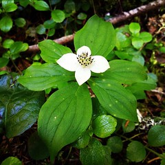
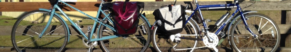
Photos I took on the trip. (click image to view larger)
Stop along the way to Crater Lake The Long Road
First Look at Crater Lake Untitled
Snag
Foot Prints Wizard Island
Garfield Peak Food Stop and Photo Time
Snow
Wizard Island from Garfield Peak Phantom Ship from Garfield Peak
Crater Lake from Garfield Peak at 8054ft Valley South of Crater Lake from Garfield Peak
Angel and Garfeild
Rocks behind Garfield Peak Wild Succulent
Flowers Home Finally! With 2 dead cellphones, and a 5 hour detour to Bend, because cause a tunnel was closed do to construction for the night on the way home.

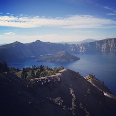
Here are some nice panoramas.(click image to view full panoramas larger)
IMG_4279
IMG_4280
IMG_4281

Angel’s Photos of Crater Lake (click image to view entire album)
Screen Shot 2012-09-10 at 12.44.02 PM

HJ Andrews Experimental Forest

Last year in my Environmental Science Class at Chemeketa Community College our professor took us to H.J Andrews for a field trip. Angel did the same trip the year before with her sister when they took the class. Since then both Angel and I have wanted to go back together and explore. This past weekend, we got our chance.

H.J. Andrews Experimental Forest is located in the Cascade mountains just west of Blue River, Oregon. Covering 15,800acres (24.68mi2), the forest is administered cooperatively by the USDA Forest Service’s Pacific Northwest Research Station, Oregon State University, and the Willamette National Forest. The forest is used for research, including long term research, as well as education, but the public are welcome to come visit and hike select trails. There is some information you should know before tromping through the forest though. (Visitor Info) I don’t believe many people come out here to hike. Most people I talk to about it have never even heard of it, with longer and more extensive trails to bike in more well known parts of the Willamette National Forest just a couple miles down the road. At HJ there are two public use trails to hike. Lookout Creek Old-Growth Trail(3.5mi one way) goes along Look Out Creek through beautiful old-growth forest. Your other option is the Carpenter Mountain Lookout Trail (1.6mi), which is a short hike, that consists of stunning views of the forests of the Cascade Mountains and Wolf Rock.  There is a lot going on at HJ Andrews, if you are interested in finding out more please checkout their site and read about the wonderful and interesting research that is going on there, along with all the other interesting information. andrewsforest.oregonstate.edu/ More links at the bottom of the page.

Angel and I hiked some of the lower Lookout Creek Old-Growth Trail, and I was able to try out my new camera mount for my GoPro that I made out of $12 worth of 7 feet of threaded PVC pipe. It helped to allow me to get higher and farther reaching camera views without unnecessarily crushing vegetation, in out of reach spots and in the water without freezing my hands off like I am used to. It worked out pretty well, I can’t wait to use it more on future adventures, hopefully more with clear water.

Here are the photos I took from our hike.
Look-Out Ridge at H.J. Andrews Experimental Forest Lookout Creek Old-Growth Trail at H.J. Andrews Experimental Forest
Bear Stump Large Stump
Weird Lichen Untitled
Another Large Stump Cornus canadensis, Canadian Dwarf Cornel, Canadian Bunchberry, Quatre-temps, Crackerberry
Fungi Deep in the trails
Log Bridge Log Stairs
Oplopanax horridum, Devil's Walking Cane, Devil's Walking Stick, Devil's Club Blue River Reservoir
Land Slide My new camera poll worked out pretty well on today's trip.

Here are some other links about HJ Andrews Experimental Forest:
Visitors, 2
Students and Teachers
Old Growth Virtual Tour
Creative Writers Collaboration
Forest Map Collection
PDF: HJ Andrews brochure
PDF: HJ Andrews Map, Backside
PDF: Lookout Creek Old-Growth Trail brochure
PDF: Max G. Geier, (1948-2000) Necessary Work: Discovering Old Forests, New Outlooks, and Community on the H.J. Andrews Experimental Forest

Biking McKenzie Pass

On Memorial Day, Monday the 29th, I got the chance to ride Scenic McKenzie Pass (Highway 242) for the first time. Being my first year in Eugene, I really wanted to do this ride. I had seen a lot of photos of other cyclists on the ride before, with the high packed snow walls; it just seem incredible. Also, last October, Angel and I had a chance to drive it while going to the OHBS in Bend, it made me really want spend more time there and revisit the Pass.

They close off Hwy 242 during the winter months due to snow. They open it back up in May for a couple weeks only to cyclists, which is a great time to venture out, because you have no fear of cars coming up the hill behind you. The pass is about 4o miles from the turnoff at 126 to Sisters, OR. I chose only to ride up to the Dee Wright Observatory, (22miles) the summit of 5325 feet elevation. 3600 feet of climbing with great views throughout of the Willamette Nation Forest, Mount Washington Wilderness Area, Three Sisters Wilderness Area, and into the Deschutes National Forest (if you continue or start in Sisters). Up towards the top there are amazing lava fields, it’s kind of crazy to think about the lava fields, and how much volcanic activity Oregon had just a couple thousand years ago. At the top, like I mentioned, is the Dee Wright Observatory where you can look out at all the amazing mountain and land formations.

Mckenzie Scenic Byway, Bike Ride

It was a super fun ride. I tend to ride a little slow, taking about 4 or 5 hours on my way up, but that includes a lot of stops for photos, food, making a couple snowmen, and just enjoying the view. It then only took about 45mins to get back down to the bottom. An incredible descent after riding that same route up. I totally recommend this ride for anyone who ever gets a chance. Just be prepared to climb a lot. Here are my photos from the ride.

Map at the ranger station Highway 242 Canopy Bicycles Only Beyond This Point Lookout Western Trillium Highway 242 USBM? Now that's a snow blower

Along the way I decided to made a couple snow men just for fun. I thought other cyclists would like the encouragement while going up and down the pass. The one in the road has 2 faces. I had to climb the snow wall to get his features, but that was really cool itself.
I made a snowman Snowman 1
I made a second snowman - face 1
Backside face 2 Snow Wall
Lichen Gets Cold Up There
Lunch 5325+ feet 5325 Feet

360 Degree View along Highway 242
360 Degree Highway 242

360 Degree View from atop Dee Wright Observatory
360 Degree Dee Wright Observatory

Here is a 360 Degree View from atop Dee Wright Observatory from the first time Angel and I drove the pass last October on our way to Bend for the OHBS. We took a lot of photos that day. I’m really glad I got a chance to ride the pass, hopefully I get to do it again.
360 degree view

History of McKenzie Pass – HERE

OHBS & Cyclocross in Bend

The Oregon Handmade bicycle show and Day of the Dead Cyclocross Festival was held this past weekend in Bend. More information about it HERE.

Angel and I went there and had a nice trip there. Here are some photos from our adventure. More below the break.

Angel at the lava fields on McKenzie Pass

Ahearne Cycles at Oregon Handmade Bicycle Show

Starting line at Day of the Dead Cyclocross Festival

More collections of photos from the trip below the break.

Continue reading

Oregon Handmade Bicycle Show 2011

The Oregon Handmade Bicycle Show is happening at GoodLife Brewing Co. in Bend, OR this year on October 29th & 30th. I have gone to the show the past 2 years in Portland. This is always a great event where builders from the Northwest can come and show off their great bikes they have built. With over 30 exhibitors, this event is put on by Oregon Bicycle Constructors Association. I will be posting photos from the event.

Day of the Dead Cyclocross Festival 2011
This event is happening during the same weekend as the Day of the Dead Cyclocross Race, which should be a great time as well. It’s happening just over a mile from the OHBS at the Old Mill District.  There are a couple other bicycle related events going on as well, full list HERE.
This should be a great time for everyone.

These events will be held at:
Oregon Handmade Bicycle Show
GoodLife Brewing
70 SW Century Ave 100-464
Bend, OR 97702

Day of the Dead Cyclocross Race
Old Mill District/Deschutes Brewery
520 S.W. Powerhouse Drive,
Bend, OR 97702

Continue reading