Angel has been spending a lot of time over the past year taking video footage and teaching herself to edit them. In November she even spoke at an event in Seattle, talking about how easy it is to take and edit videos with whatever gear you have.
Along with taking photos, Angel started taking some simple video with her basic Canon Powershot SD1400 IS. The camera took pretty nice video, 720p HD. She used the camera every day and it has the wear marks to show for it.
She replaced the camera in April, after the camera focusing motor started to act up and make weird noises, a couple weeks after that she accidentally dropped the camera, cracking the screen. It was time for a new one, so she bought the Canon Powershot 110HS. This was a nice up grade for her. Allowing for full 1080p HD video shooting. She has taken a lot of great photos and videos with the camera. This is what she currently uses for almost everything.
Along with those cameras, she also occasionally uses the GoPro HD Hero I picked up at an REI Garage Sale last year. We have been able to take a lot of great video with this.
With the use of these cameras, and her MacBook Pro with iMovie, she is able to make these great little videos. In the past couple weeks she has made some of my favorite videos.
In Monday Tradition, she simply filmed what she did on Mondays, when she’s not at school, and I’m at work. Featuring one her favorite places to get vegan biscuits and gravy, Wandering Goat.
Mount Pisgah Hike, last week we spent a couple short hours, while it was dry out, hiking around Mount Pisgah.
Winter Soup, This is a great short little video of her making soup. She makes a big pot of soup almost every week, then eats it thought the week. A friend had asked her how she makes it. She had a great creative way to share it with them. You can read about it, and see the recipe HERE.
You can watch more of Angel’s great videos by going to my BreadBikeBlog YouTube Channel. Most the videos on there have been made by Angel. Some she helped me with, but now because of her I can help shoot video footage and help her produce great videos.
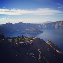
A month ago Angel and I took our first trip to Crater Lake. I haven’t had time to post anything about the trip or the photos until now. It started out as a nice simple trip to Crater Lake, stopping off in Oak Ridge along the way. Spending a nice time climbing Garfield Peak. Then ended the day with missing our one way home and having a super long adventure. Here is a good write up Angel wrote.
Writen by Angel,
On Austin’s day off, we decided to go on an adventure, and visit Crater Lake, the deepest lake in the United States, and one of the deepest in the world. Crater Lake was formed when Mount Mazama (a volcano) erupted and collapsed in on itself, forming a caldera, that over time filled up with water from rain and snow, and is now a national park. Crater Lake is sacred to the Klamath Native American tribe. No rivers flow into the lake, and none flow out, which is a major reason for the pureness of the water in Crater Lake. The eruption that formed Crater lake took place over 7,000 years ago, however there is still thermal activity present on the lake’s floor. There is a 1 in 300 chance of another eruption at Crater Lake occurring sometimes during the next 30 years. Interesting, the lake contains a couple of volcanic cinder cones, the most visible being Wizard Island. Boat tours to Wizard Island are available in the summer months (although Austin and I didn’t partake this time!). We hiked Garfield Peak, which was 3 miles roundtrip, with a gain in elevation of over 8,000 feet! We stopped to rest a couple times, my favorite being when we found a rough rock bench in the shade of an evergreen tree, where I ate half of the sandwich I brought. I kept thinking we had made it to the top, but the trail went on forever. Despite the heat (I think it was 90 degrees the day we visited), there are still huge patches of snow present all over Crater Lake, that are shaded from the sun most of the day. I made a snowball and threw it into a puddle of melted snow. Eventually we made itto the top, and the view was gorgeous. We made our way back down, which was quicker than the way up. Because cell phone service is spotty away from the cities, both of our cells phones suffered. Mine died while we were hiking because I didn’t think to turn it off, and Austin’s was nearly dead. We headed home around 7 o’clock. We got to see a gorgeous sunset over the hills, the whole sky was pink for a little while. We were going to stop for some gasoline, but were excited when we saw that we could just make it into town with what we had in the tank. Gas is pricier the farther away from the main cities you get ($4/ gallon near the lake, compared to $3.50/ gallon in Eugene). When we reached the tunnel at the halfway point, we found it closed for the night (at 8, and we got there at 8:30), to reopen at 6am because of construction. I wasn’t that worried, mostly because I am ignorant of directions, and because we have a GPS for instances like this, to direct us to alternative routes home. Unfortunately, this tunnel is the only way to get back to Eugene, without driving back the way we had come, towards Crater Lake, or to Bend (which was over an hour away, and then nearly 3 away from Eugene). So, when we were an hour and a half away from home, we had to consider our options. We tried to decide whether it would make more sense money-wise to try to get a room at an inn for the night, than having to buy another full tank of gas to get us to Bend and home. Because Austin had to work in the morning (not to mention all the hotels we passed were full), we attempted to track down a gas station, which isn’t easy when you’re driving through national forests. My car has a small gas tank. It can hold 10 gallons or so, and I fill it up when it hits 300 miles. We were on 270, and desperately trying to find a close gas station in the GPS. The closest were 30 miles away, and with dead cell phones we couldn’t look up the phone numbers in order to call to make sure they were open. We finally got the GPS to find a Shell that was 15 miles away, and we drove there, hoping that the un updated GPS wasn’t taking us to an old station that no longer existed, and hoping that this one would be open, if it existed. This was probably the scariest part of the adventure. If we had made it there and it had been closed, we would’ve had to sleep in the car until they opened in the morning, because we didn’t have enough gas to make it to any other stations. In a stroke of luck, they were open, and we filled up the tank and asked if there were any other way of getting home without going through the tunnel. The gas station attendant told us our options were to head for Bend, or to go down to the very southern tip of Oregon, near Medford, and to come up that way. We chose Bend, because we’ve driven through it before. Forest roads at night are terrifying. We saw deer a few times, grazing at the edges of the forest near the road. The roads are unlit, so we drove with our brights on the whole way. Austin drove us to Bend, and we stopped at a Shari’s 24 hour diner. Austin and I had eaten all of our sandwiches on our hike, and were getting very hungry, especially knowing we wouldn’t be home for another few hours. I got hash browns (vegan eating on the road is very limited), and he had a bunch of breakfast food (he swapped the meat in a combo breakfast for pancakes). I took over driving home from Bend, and managed to get us home safely. For the first hour I was so nervous, there are deer signs everywhere, and elk signs as well. I’ve been in a car that’s collided with a deer, and I know the consequences. Hitting a deer in the middle of the night, in the woods, with no cell phones was not an option. I drove super cautiously. Luckily there weren’t too many other people on the roads so I could keep my brights on. By the time we made it back to Eugene (at 2 in the morning), I was more awake than when we left Bend (from all the singing, at least our iPod was charged fully), and feeling so thankful to have made it home safely. That was way more of an adventure than we were looking for.
Other than the unexpected longer trip home, the day was amazing, and to look back at it a month later I wish we had time to go on a trip like this again before the summer ends (minus the roadblock at the end, of course). Sadly, we probably won’t get to do a trip quite like this for a while.
Last year in my Environmental Science Class at Chemeketa Community College our professor took us to H.J Andrews for a field trip. Angel did the same trip the year before with her sister when they took the class. Since then both Angel and I have wanted to go back together and explore. This past weekend, we got our chance.
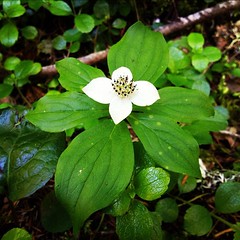
H.J. Andrews Experimental Forest is located in the Cascade mountains just west of Blue River, Oregon. Covering 15,800acres (24.68mi2), the forest is administered cooperatively by the USDA Forest Service’s Pacific Northwest Research Station, Oregon State University, and the Willamette National Forest. The forest is used for research, including long term research, as well as education, but the public are welcome to come visit and hike select trails. There is some information you should know before tromping through the forest though. (Visitor Info) I don’t believe many people come out here to hike. Most people I talk to about it have never even heard of it, with longer and more extensive trails to bike in more well known parts of the Willamette National Forest just a couple miles down the road. At HJ there are two public use trails to hike. Lookout Creek Old-Growth Trail(3.5mi one way) goes along Look Out Creek through beautiful old-growth forest. Your other option is the Carpenter Mountain Lookout Trail (1.6mi), which is a short hike, that consists of stunning views of the forests of the Cascade Mountains and Wolf Rock. There is a lot going on at HJ Andrews, if you are interested in finding out more please checkout their site and read about the wonderful and interesting research that is going on there, along with all the other interesting information. andrewsforest.oregonstate.edu/ More links at the bottom of the page.
Angel and I hiked some of the lower Lookout Creek Old-Growth Trail, and I was able to try out my new camera mount for my GoPro that I made out of $12 worth of 7 feet of threaded PVC pipe. It helped to allow me to get higher and farther reaching camera views without unnecessarily crushing vegetation, in out of reach spots and in the water without freezing my hands off like I am used to. It worked out pretty well, I can’t wait to use it more on future adventures, hopefully more with clear water.
Last week I took a short trip to visit my brother in his new home in Phoenix (Scottsdale), Arizona. It was a fun time and my mom and little sister were out there visiting as well. To me, Arizona was too hot, but there was still a lot of cool vegetation growing around the city.
Angel made a video of the hike we did up Spencer Butte in January after the first good snow. It was our first hike on the butte and a great time. We can’t wait to get to go hike up it again.
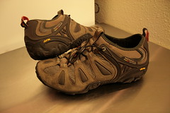
Last week (1-16-11), Angel and I decided to go hiking on Spencer Butte for the first time since we moved to Eugene. We can see the butte from our home, with it just being 4 miles away. I have ridden my bike around it, but we just haven’t ever gone hiking there. Eugene seems to have enough inside the town to keep us busy for quite some time. With the snow falling the day before, we really wanted to get in the hills to get good photos of it. I got great use out of my new Merrell shoes in their first real hike, and I used the GoPro with its head mount to get some nice photos and videos on the hike. The video of the hike will be posted later.
Panorama Photos
I also took some great panorama photos. Follow the links below to view them in their entirety.
• 360° spherical view on the path up the butte in the woods on the trail(Here).
• 360° view up at the summit(Here).
Saturday December 31st, 2011 was the REI Year-end Garage Sale in Eugene. This is a big sale at REI, where they sell slightly used gear, returns, and display items. This was the first time I have been able to go to one myself, and let me just say it was well worth the short wait in line to get in. There was a lot of great gear to pick up there and I got myself some presents that I’m quite happy about.
ALPS Mountaineering Mystique 2.0 – MSRP $199.99 bought at $9.83
This is the first real tent I have ever bought, but it seems like it will be perfect for me: 3 season, fits 2 people, pretty light at 5lb 2oz total, packs pretty small. I’m quite excited, the only thing is the tent was not cleaned up before packing away after the last use, so it smells like the outdoors (Angel claims it smells like mossy earth and radishes). No visible mildew, but I should clean it as soon as possible. If anyone has any ideas on how to clean it in the middle of winter, indoors let me know. The biggest problem right now is all the rain we’re getting, so I can’t set it up outside to clean it out and hang. So I’ll need to do this inside maybe in stages. If I can’t get it cleaned out well enough it’s no big loss, it was $9.83.
Novara Arosa Bike Gloves – MSRP S29.50 bought at $9.83
These gloves fit very well and should be a great cool and dry weather glove, when my Novara Stratos Bike Gloves are just too warm. On the tag, the reason for return was “not warm enough”, but these will work well for me. They just needed a little stitching fix, and now they are perfect. I can’t wait to get to use them this coming spring.
Merrell Chameleon3 Stretch – MSRP $120 bought $19.83
The shoes are hardly broken in and all the tread is there, including the fine tread that wears off fast. They should be great for hiking and walking.
GoPro HD HERO Camera – MSRP $239.99 bought $99.83
It was a big surprise for me to find this, and it was a hard decision to get it but I did. Angel and I shoot lots of videos together and we have always talked about getting one. This price was too fair to pass up. I can only imagine no one got it before me because: A. They didn’t know what it was, or B. They don’t do video editing themselves. The camera is in perfect condition. The reason for return was “didn’t like product”, and I don’t really know why they didn’t like it, but I like it already. It has HD video up to 1080p at 30fps, with 127º wide viewing angle. 60fps at 720p and WVGA resolutions allowing smooth slow motion playback with 170º wide viewing angle. With a waterproof case allowing it to go to depths of 180ft (60m), my Fuji XP10 depth is only 10ft (3m). Comes with mounts, including a one for vented helmets. This should get a lot of good, fun video footage that we can use. Great for long bike rides, or trips to the coast. Can’t wait.
I’m excited to get to use these new items and after I will write reviews for them, so stay tuned. There will be new videos as well with the help of the GoPro Hero.
I grew up in central Illinois. In August of 2007, I bought my first real “adult bike” after needing a bike to save money on gas. Since then I have had many bikes. In April of 2010, after moving out to Oregon, I got my beloved Surly Long Haul Trucker. I have put a lot of good miles on the bike. This blog is about my life in Eugene.