Tag Archives: app

Photo: February Adventures

Throughout the month of February I took a lot of great photos that I never used in any of my posts here. So instead of letting them fade back into the darkness of Flickrs past I have collected them all here for anyone interested. February was quite eventful this year. I ended up going on a couple good long rides with friends as well as by myself. I had some good foods I haven’t had in a long time, like a Voodoo Doughnut. And had some great finds like a compost bin and  roller trainer.
Now, on to March for even more exciting new adventures for me.

If you don’t use or follow me on Twitter, or have the Instagram app for the iPhone you can always find these photos and more in my Flickr Album: Instagram.

GreenCycle Services Christmas Tree Pick Up Peanut Butter Sandwich Easter Island Head Spencer Butte Willamette and Fox Hollow Bill's Bench Country Road Shed At My Back - The Sunset Tri-Color Rotini - after ride meal. Moon Mountain City Park Tires - I just learned Moon Mt. City Park seems to be nothing more then a tire dump. How fun. Boat Protected Natural Area The Moon Hendricks Park Smoothie YUM!!! Bikes Contents of an Owl Pellet Working Glasses - the best My Birthday Dinner Book Eating Robot Glazed Doughnut - it's been too long Angel's New Robot Necklace Pizza Heart Skinner Butte Climbing Columns Up Close Rode Up Skinner Butte 10 Times - Unofficial World Record Early Morning Ride Connecting Communities Sponsors Magazine & Newspaper Room Ceiling Added Reflective Tape to My Rims Bridge Tower Angel and Her Linus Me and My Surly Best Buy's Bike Racks are Full Taking a Break From The Rain Vanilla Shake Rain Cape into Rain Cover - securely locked Squid!!! Found a nice large compost bin on the side of the road for free. On My Way Home Glass Yehuda Moon & The Kickstand Cyclery - Patch and Books Pot Tower My Bike Takes Me Places That School Never Could Velomobile Bikes Outside The Job Fair Out For A Ride Boca Burger with Onions and Fries Got a CycleOps Roller Trainer on Craigslist Today. Now I'm riding it in the kitchen, I'm pleased. To Much Smoothie - What's a boy to do? Smoothie Cube Starter Work

Instagrams into StickyGram Magnets

#StickyGram Magnets Just Got Here, Angel Loves ThemMost people know what Instagram is by now, whether they use it themselves with their iPhone, or are bombarded by their friends’ photos being posted on their social media of choice. It’s a nice way to take photos with some style and post them quickly. StickyGram is a company that will take your Instagram photos and make them into magnets. There are a growing number of other companies out there that do similar services, but I decided to go with StickyGram magnets as a Valentine’s gift for Angel. I ordered them on the 13th and got them the 21st, just over a week to get them, which is great, especially since they came from London, England. The overall quality of the magnets are really nice. The magnets are strong and the image quality is great (although I assumed they would be glossy, and they are matte). The image has a white border around the image. It would be nice if the image had a full bleed (image goes to the edge) so there would be no added w#StickyGramhite, or an option for a black border. I will say one of the magnets dropped and hit its corner. In that corner the image is slightly peeling back. 😦 Other than that, they are great. When I get more nice photos, I will probably make some more.
You can purchase the StickyGrams for $14.99, with free shipping, for a sheet of 9 photos.

You can see all my Instagrams in my Flicker Album.

Ride the City iPhone App

Screen Shot 2012-02-05 at 7.07.37 PMI was given the opportunity test out the Ride the City iPhone App and have a couple extra copies to share with my followers. (More about how to receive a free copy below the page break)** These are my first thoughts and initial write up for the app. I will write an in depth review on the app after I get to use it a little more. Some of you might be familiar with the Ride the City bicycle route map site. The iPhone app allows you to do the same thing, on the go from your phone. The RTC app has been out since April of 2010. They just recently came out with Version 1.5 which has a lot of great new features.
Weather:
• Check in app before your ride
• Fully featured weather forecast for the day
Layers:
• City bike routes, lanes, and paths
• Bike shops
• Bike share stations
Easy Drop Markers:
• Touch screen to drop start/end markers
• Great if you don’t know the exact address

The map and routing for the site and app is based on Open Street Map. Ride the City bike path and lane distinctions are a lot nicer than the ones Google’s Bike Routing feature does. Google uses light green for bike lanes, light green dashes for safer recommended routes, and dark green for off road bike paths and trails. So it tends to be a lot of green. The Ride the City maps use blue for bike lanes, blue dash for safe routes, and green for for off road bike paths and trails. Currently, the App only works for 38 cities, the same as the Ride the City site, which are all listed out after the page break.

The Ride the City iPhone App can be purchased for $1.99.
The Ride the City website itself is free to use.
Both are only currently available for 38 cities.

Chance to get the app for free below the page break.**

Continue reading

Snow on Spencer Butte

Last week (1-16-11), Angel and I decided to go hiking on Spencer Butte for the first time since we moved to Eugene. We can see the butte from our home, with it just being 4 miles away. I have ridden my bike around it, but we just haven’t ever gone hiking there. Eugene seems to have enough inside the town to keep us busy for quite some time. With the snow falling the day before, we really wanted to get in the hills to get good photos of it. I got great use out of my new Merrell shoes in their first real hike, and I used the GoPro with its head mount to get some nice photos and videos on the hike. The video of the hike will be posted later.

Panorama Photos
I also took some great panorama photos. Follow the links below to view them in their entirety.
• 360° spherical view on the path up the butte in the woods on the trail(Here).
• 360° view up at the summit(Here).

*Update: Video from the hike(Here).

Photos of the hike and climb up to the summit of Spencer Butte, Flickr Set.
Snowman Snowman 2 Hours Later Snow Fern 1-16-12 Foot 365 Little Snowman Trees Angel Summit Snowman Our Home Angel at the Summit

Review: Moleskine Planner

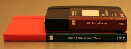
Moleskine Planner - side
Moleskine is a producer of legendary notebooks. Originally handmade by French bookmakers, Moleskine has a lot of history behind them, being used by the likes of Oscar Wilde, and Vincent van Gogh. Sadly, in 1986 the Moleskine style notebook died out. In 1997, a small company started reproducing these notebooks, and in 2006 Moleskine became the company we know today. Making a wide range of notebooks, planners, travel notebooks, and other specialty notebooks. Now there is even a digital form of this beloved paper book as an App.

I have used a couple different notebooks, using the larger notebooks for drawing and note taking, and the pocket sized notebooks for ideas. But the one I use the most is my Moleskine 12 Months Weekly Notebook Diary/Planner, red hard cover, large. I have used this same planner each year for the past 3. Angel had given me tMoleskine Planner - 3 weeklyhe first one in 2010. I used it for it at first just for writing down events, but after I moved to Oregon in the spring and bought my LHT it has been used everyday to keep track of my miles and time ridden on my bike for that day.   Angel got her own extra small (pocket sized) Moleskine 12 months Daily Diary/Planner, with a black soft cover.

Moleskine consists of great features for useful planner. The first few pages consist of a list of international codes, holidays, conversion charts, time zones, and travel log. The pages are nicely organized, whether it’s a daily, weekly, or monthly planner in any size. In the back they have a small pocket to store loose notes. The larger planners come with a removable lined booklet that can be used for anything. When I got my first Moleskine planner you could get any color, as long as that color was black (a la Henry Ford). The red was special, so that is the one I got. In the past 3 years Moleskine has started producing planners and notebooks with covers in every color imaginable, as well as embossed designs to choose from, with multiple page layouts (graphed, lined, blank, ect.). So you’re likely to find one that fits your style and need.

Moleskine Planner - covers Moleskine Planner - open daily
Moleskine Planner - open weekly Moleskine Planner - used open

Review: New Bike Maps App for iPhone

Bike Maps A new app has been released recently to help with navigation on your bike if you own an iPhone. Bike Maps – Bicycle Directions for Commuting and Touring by Burning Robot is the new app offering turn by turn directions for bikes.

This is a review for Bike Maps Version 1.o.1 (12-13-11), I will try and do updated reviews if and when the newer versions are available.

Features
• Turn by turn directions
• Search by keyword or address
• Get bike directions from your current location
• Prioritizes bike paths and lanes
• Avoids busy streets

I downloaded this app for $1.99 to try it out myself. The app uses the power of Google Map’s Bike Route feature. Over all this app is very clean, and works fast over 3G cell service, but might be lacking some features some people might like. Some of what it is lacking is due to some flaws with Google’s Bike Routing, some are things the app developers might have not decided to add in.

The app is quick to access. Runs well pulling up maps over the 3G. When you open it up it takes you straight into the map, with a Search/Address bar at the top. Pretty bare bones which can bee good. You simply type in what you want in the search bar. Say “bike shop” it will give you the shops in your location, just like Google would. You click the pin on the map then it brings up information about that location, and you can just click the “Bike Directions” button on the page. From your current location only, you will be given a single suggested bike route to that location (the best bike route, according to Google, including distance, and time it will take). The route is highlighted on the map and the written directions are shown one at a time at the top of the screen, allowing you to see the map and directions at the same time. You then can click through arrows at the top right to use the turn by turn directions, which give you the distance and where to turn each step of the way.

Bike Maps App - First Screen Bike Maps App - Zoomed In Bike Maps App - Bike Shop Bike Maps App - Bike Shop Selecte Bike Maps App - Info Bike Maps App -  Bike Shop Distance and Time Bike Maps App -  LBS 2 of 10 Bike Maps App - LBS 4 of 10 Bike Maps App - LBS End

Here are some things the app is lacking in comparison to the full desktop version of Google’s Bike Route feature. It doesn’t show highlighted bike routes, instead it just shows the standard map view. It would be nice if it showed the highlighted map view, then you could use it to plan your own routes. The app also doesn’t suggest multiple routes to choose from, it uses the very first route that would come up if you used the full desktop version. This can be bothersome because in many situations the first choice Google suggests is not the best one. Also there is no way to edit routes yourself. And the app only allows you to get directions from your current location. For the most part this will be fine, but it would be nice to be able to plan out routes from other locations.

I like this app even with what it might lack right now, it’s a good, straight-forward bicycle routing app and it lets you use Google’s Bike Routing feature on your iPhone. So if that is what you want, this will work for you. Also, there are no ads, which is always good.

Available on the App Store

To Burning Robot LLC or the developer:
I have not found a way to contact you. I would like to find out more about what they are working on. So if you are out there please contact me.

iPhone 4S

iPhone 4S

iPhone 4S, side

Like many others today, I received my iPhone 4s. I plan on trying out and reviewing a lot of the Bike Computer/GPS apps that you can get for the iPhone. Along with some different bike mounts/cases. This will hopefully good comparison of what bike apps for the iPhone, to help people chose the one that is right for their needs.

With all these Apps and accessories you can get the iPhone is a perfect choice for cyclists. This phone has great GPS/Mapping capabilities, battery life, and a great 8mp camera with 1080p video. It would be great to do everything on bike tours.

I have enjoyed the phone so far. Just waiting to get some cases to feel safer using it on the bike before starting the reviews. Here are the first videos I took with the iPhone when I was riding along the river on the bike path.

iPhone 4S Video – Caterpillar Footage

iPhone 4S Video – Caterpillar Footage 2